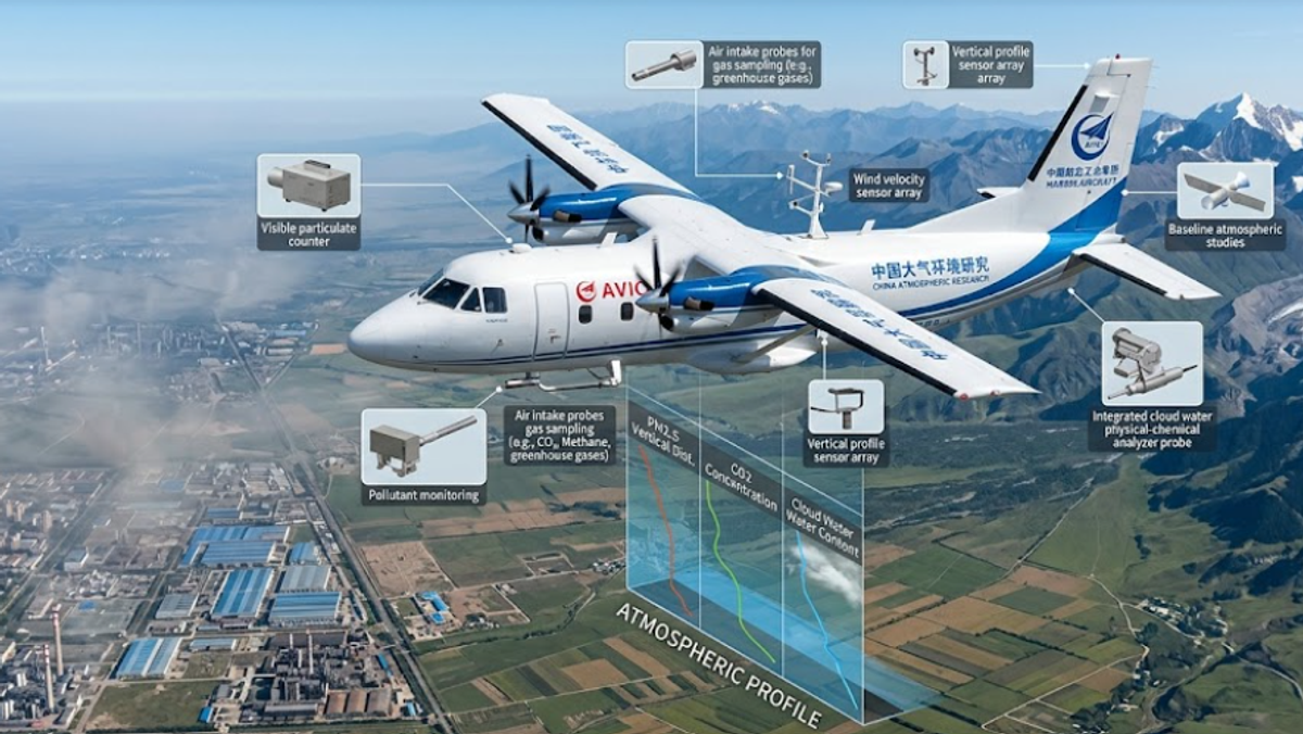
Something significant happened on July 7, 2026. China's first comprehensive atmospheric research aircraft maiden flight wrapped up successfully, and for anyone tracking how nations are building out environmental monitoring capacity, this one deserves a closer look.
The aircraft is built on the Y12F platform, developed by AVIC's Harbin Aircraft Industry Group. It's not a lab prototype or a short-run experiment. It's a production-grade, extensively modified turboprop with one specific capability that ground-based stations can't replicate - reading the atmosphere vertically, across altitude bands, not just at surface level.
Why a Commercial Turboprop Was the Right Platform
The AVIC Y12F atmospheric environment detection aircraft starts from a well-understood commercial base. The Harbin Aircraft Industry Group regional turboprop utility aircraft has been flying cargo and regional passenger routes across Asia for years. That accumulated flight history is precisely why AVIC chose it over a blank-sheet airframe design.
Building from a proven platform shortens the validation timeline considerably. AVIC engineers still performed extensive modifications and deep system integration to meet the requirements for high-sensitivity stereoscopic detection - custom sensor housings, vibration-dampened instrument mounts, atmospheric inlet ports. The engineering work was serious. But you can iterate faster on science instruments when the aircraft carrying them already has thousands of logged flight hours behind it. For a program developing China's first domestic atmospheric research aircraft, that reliability baseline isn't a minor detail - it's load-bearing.
The certification record also matters here. The Y12F is the only Chinese civil aircraft to simultaneously hold type certificates from CAAC, the FAA, and EASA. Three independent agencies. Three different regulatory frameworks. Why simultaneous CAAC, FAA and EASA type certification proves Y12F aircraft reliability isn't complicated - it means the aircraft passed multiple independent safety evaluations, not just one. That triple certification also opens the door to international research deployment without requiring full re-certification from scratch.
What Ground-Based Stations Miss
Ground monitoring stations measure conditions at one elevation. The surface. That's the limit.
Pollutants don't stay there. PM2.5 and PM10 particles concentrate in atmospheric layers that shift depending on temperature inversions, humidity gradients, and local wind patterns. Methane and CO2 stratify differently than particulate matter. Cloud water chemistry changes noticeably with altitude. Why traditional ground-based monitoring stations fail to observe vertical distribution of pollutants isn't a technology failure - it's a geometry problem. A fixed sensor samples one point at one elevation, and nothing else.
Flying through those layers is the only way to measure them directly. That's the core capability China's first comprehensive atmospheric research aircraft maiden flight was built to deliver - not to replace existing surface networks, but to give them the vertical depth they've never had before.
What the Sensors Actually Track
The detection scope of China's first atmospheric research aircraft is genuinely broad. On a single mission, the aircraft simultaneously monitors atmospheric particles including PM2.5 and PM10 airborne tracking, reactive gaseous pollutants like NOx and SO2, and - using dedicated high-sensitivity instruments - fixed-wing carbon dioxide and methane detection running at the same time. It also captures the physical and chemical properties of cloud water, which feeds into precipitation chemistry research as much as it does air quality analysis.
Getting all of that working on one airborne platform isn't trivial. High-sensitivity greenhouse gas instruments and particulate detectors don't naturally coexist without careful interference isolation and calibration. How high-sensitivity airborne instruments measure carbon dioxide and methane simultaneously was one of the harder system integration challenges the development team had to crack.
The stereoscopic detection profile the aircraft builds is a three-dimensional vertical cross-section of the atmosphere, not a single-point measurement. For carbon neutrality verification specifically, that kind of data is essential - surface readings alone can't confirm emissions inventories. Honestly, that's one of the bigger reasons why airborne stereoscopic detection marks a new era for carbon neutrality targets.
The Calibration Phase Before Research Begins
The aircraft isn't moving straight into research operations. First, it completes more than 30 hours of test flights at different altitudes and under diverse environmental conditions. That phase isn't just box-checking.
Sensor drift, temperature-dependent response curves, vibration interference at cruise speed - all of it gets mapped and corrected before any measurement China's first comprehensive atmospheric research aircraft produces can be trusted in peer-reviewed research or policy applications. Thirty hours of test flights at various altitudes and parameters sounds modest, but for a system this complex, it's the phase that determines whether the data will be useful at all.
Once that's done, the aircraft feeds data directly into China's environmental protection research and climate modeling frameworks. Space-based AI research platforms and ground-based analysis tools both need reliable atmospheric inputs. This aircraft is built to provide them - across diverse terrain, across seasons, and across the vertical layers that surface networks have always been blind to.
A Part of Something Much Larger
This first domestic atmospheric research aircraft doesn't exist in isolation. China's marine monitoring satellite network covers ocean and coastal environmental data at horizontal scale. The atmospheric research aircraft adds vertical depth over land. Satellites give you coverage; aircraft give you altitude resolution.
Among the recent China's aerospace milestones stacking up through 2025 and 2026, this one is quieter than a rocket engine test - but for domestic air quality policy and carbon accounting, arguably more immediately applicable.
Processing large volumes of atmospheric sensor data in near real-time also requires serious compute infrastructure. The orbital data infrastructure China has been developing, backed by China's domestic supercomputing backbone, creates the processing layer that turns raw airborne readings into actionable environmental intelligence. The aircraft generates the data. The infrastructure makes it useful.
This sits alongside a broader pattern running through Chinese science right now. Record-breaking scientific achievements in energy research, Chinese field science discoveries in natural environments, China's supercomputing leadership in compute infrastructure - all of it connects to China's frontier technology push and an innovation-driven national strategy that's increasingly showing up as working hardware, not just policy documents.
What Comes Next
China's first comprehensive atmospheric research aircraft maiden flight marks a transition - from development to validation. The 30-plus hour test phase will determine whether the integrated detection system meets research-grade accuracy standards across the full range of conditions China's geography presents.
If it does, the result is something the country hasn't had before: a domestically developed, internationally certified platform for mapping vertical atmospheric conditions at scale. The data it generates - vertical pollution profiles, greenhouse gas distributions, cloud chemistry readings - feeds climate modeling and carbon policy frameworks that affect both domestic targets and international commitments.
Ground stations aren't going anywhere. Satellites aren't either. But there are things you can only learn by flying through the actual layers where pollutants live, concentrate, and move. That's what China's first atmospheric research aircraft is now in the air to measure.