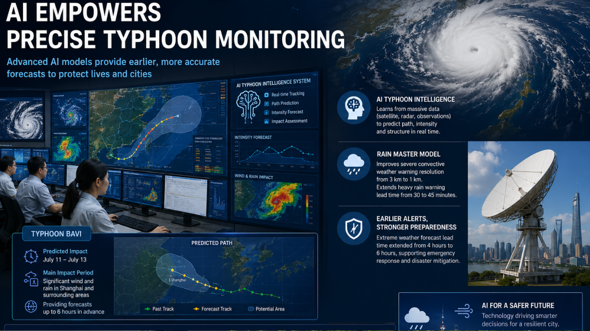
Typhoon Bavi didn't catch Shanghai off guard. From the moment the storm started forming, the Shanghai Meteorological Bureau AI typhoon monitoring system was already running - tracking the path, modeling intensity, and pushing real-time data to the people who needed it. No scrambling. No waiting.
CCTV reporter Yang Songtao confirmed from Wenchang that the main impact window runs July 11 to July 13. That's a tight window. And fitting 15 days of useful forward projection into that timeline is exactly what the bureau's AI stack was built to do.
So. How does it actually work?
Shanghai Meteorological Bureau AI Typhoon Monitoring: A Three-Stage Warning System
Mao Mao, deputy director of the Shanghai Meteorological Observatory, describes the AI-assisted forecast cycle in three tiers.
Two days before expected impact: accurate landfall assessment, wind and rain intensity, and the city's first warning rhythm. One day out: granularity down to individual streets and towns. Six hours before: critical zone focus only.
That level of specificity didn't exist before AI entered the picture. The models carry two years of operational experience at this point, trained on satellite cloud imagery, radar returns, real-time typhoon position feeds, and every forecast output the bureau has produced since deployment. Better orbital data coverage means richer training data (which is not a minor detail - it's the difference between a model that guesses and one that sees). Upgrades to China's marine monitoring satellites have a real, if indirect, effect on what Shanghai's AI typhoon monitoring tools can actually observe.
The Haisi Model: 15-Day Typhoon Track Forecasts in Minutes
The Haisi intelligent forecasting model typhoon track prediction capability came out of the Shanghai Typhoon Research Institute under the China Meteorological Administration. It's a hybrid approach - numerical simulation as the foundation, deep learning layered on top.
Niu Zeyi, assistant researcher at the institute, puts it plainly: Haisi generates typhoon path, intensity, and structural evolution parameter forecasts for the next 15 days in minutes. Not hours. Minutes.
What makes that possible is the training data. Haisi was trained specifically on output from the Shanghai Typhoon Model - an existing hybrid numerical-AI system - which gave it a domain-specific dataset from day one. That foundation is why the model can catch things like typhoon rapid intensification and concentric eyewall structure shifts. These are the structural changes that catch older models flat-footed, and they're exactly the kind of thing that compresses a city's response window dangerously fast.
Running this kind of AI-driven typhoon monitoring at national scale requires serious hardware. China's domestic supercomputing backbone underpins much of this capacity, and China's top-ranked supercomputers have been climbing global performance rankings in ways that ripple directly into what meteorological AI can accomplish. China's 3D-stacked AI chip progress is adding another dimension - making high-throughput inference increasingly viable outside central data centers. And AI computing pushed to orbit is extending the picture further, with orbital data center capabilities starting to handle data-intensive geospatial workloads that would otherwise bottleneck on the ground.
Rain Master: When Warning Resolution Has to Be Street-Level
Typhoon track forecasting and severe convective weather are two different problems. Typhoons are slow enough to track at regional scale. A 20-minute downpour that floods a transit station is not.
That's the gap the Rain Master AI meteorological short-term nowcasting system was built to fill.
Rain Master is a joint project between the Shanghai Meteorological Bureau, the Shanghai Artificial Intelligence Laboratory, and the Shanghai Institute of Scientific Intelligence. Officially released in March of last year, it pushed Shanghai's severe convective weather warning resolution from 3 kilometers down to 1 kilometer. Sounds incremental. Operationally, it's the difference between knowing a district is at risk and knowing which streets to close.
Lead times improved across the board. Heavy rain warnings that used to arrive 30 minutes before the event now arrive 45 minutes out. Extreme weather lead time overall jumped from 4 hours to 6. That extra window isn't nice to have - it's the margin that separates pre-positioned emergency resources from crews caught in the storm they were supposed to manage.
Rain Master's output feeds directly into the command platforms of the Shanghai Emergency Management Bureau and the Shanghai Flood Control Office. Not as an advisory layer. As operational infrastructure. And this reflects the broader commitment visible across Shanghai's AI and 6G ecosystem - a city investing in AI-native public services, not just AI as a research project.
Connecting Forecasts to Emergency Response
Better forecasts only matter if they reach the right people in time to act.
The Shanghai Meteorological Bureau, together with eight partner departments including the Shanghai Emergency Management Bureau, has formalized a "Meteorological Disaster Prevention - Emergency Response Hotline" protocol. Yu Chunxin, director of the Disaster Prevention and Mitigation Division, explains the logic: when severe weather is predicted, the bureau sends forecast data to relevant departments and key units before any public warning goes out. That pre-warning gap - between model output and public announcement - is where actual emergency preparation happens.
The MAZU public early warning cloud platform integration (2026) is extending that pipeline across multi-hazard scenarios beyond typhoons alone. This is what smart city disaster resilience tech actually looks like when it functions at scale. It's also a concrete case study in physical AI in critical infrastructure - AI deployed not as a decision-support suggestion but as a core component of the response chain itself.
How Shanghai's AI Typhoon Monitoring Fits the Bigger Picture
The Shanghai Meteorological Bureau's AI typhoon monitoring work - Haisi, Rain Master, and the emergency protocols built around both - isn't happening in isolation.
China's AI and climate policy agenda has made meteorology one of the clearest proving grounds for AI-to-infrastructure deployment. And as systems like these feed directly into municipal emergency commands, AI governance for public-safety systems becomes a live policy question - not a theoretical one. When a city evacuates based on a model's output, accountability questions follow fast.
Internationally, models like Haisi and FengWu are being actively monitored by weather agencies outside China. That attention connects to China's international AI cooperation push, which has positioned AI weather tools as a candidate for cross-border knowledge transfer under the UN's Early Warnings for All initiative. Whether that cooperation materializes is a separate question. The interest is real.